

Open User Map
Turn your WordPress site into a community-powered map where visitors add and manage locations with easy approval workflows.
About Open User Map
Open User Map is a powerful, interactive mapping plugin for WordPress that lets you create a map your visitors can actively contribute to. It is designed for anyone who runs a WordPress site and wants to add a community-driven map without needing coding skills, a Google Maps API key, or a complex setup. The plugin transforms a static map into a living, collaborative tool where users can add and edit locations, submit details, and help keep your map accurate and up-to-date. With over 15,000 active installs and a perfect 100% five-star rating, it is the number two map plugin on WordPress.org, trusted by site owners worldwide.
The main value proposition of Open User Map is its simplicity and power. You can get a fully functional, user-submitted map running in minutes, not hours. It handles everything from frontend submissions and approval workflows to advanced categorization, custom fields, and even the ability to use custom images as maps. Whether you are building a local business directory, a community event guide, a tourism map, or a campus floor plan, Open User Map gives you the tools to create exactly what you need. The plugin also offers a Pro version with even more advanced features, but the free version is robust enough for many common use cases. It is a friendly, approachable tool that puts the power of mapping into the hands of every WordPress user.
Features of Open User Map
Frontend Location Submissions and Editing
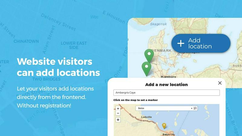
Enable your website visitors to add and edit locations directly on your map. When a user clicks the "Add location" button, they can place a marker and submit details like a title, description, and custom fields. These submissions then go into an approval queue, so you have full control over what goes live. The editing capability allows users to update their existing locations, ensuring the map always reflects the most current information without you having to do all the work.
Effortless Categorization and Filtering
Organize your map by grouping locations into marker categories, each with its own unique icon. This makes your map visually clear and helps visitors quickly understand what is where. For example, you could have categories like "Restaurants," "Parks," and "Parking." The filtering feature allows visitors to show only the types of locations they are interested in. Each location can belong to multiple categories, giving you great flexibility to represent all relevant attributes.
Lines and Areas
Go beyond simple point markers by adding routes, paths, zones, and regions to your map. This feature is perfect for highlighting trails, service areas, event grounds, neighborhoods, or construction zones. You can draw lines and polygons directly on the map, and distances and area sizes are calculated automatically. This makes it easy to communicate spatial information at a glance, such as the length of a hiking trail or the size of a festival area.
Custom Image as Map
Upload any image and transform it into a fully interactive map. This could be an overlay, a floor plan, an event layout, a game map, a product diagram, a campus guide, or a seating chart. Users can then place markers directly on top of the image with the same powerful functionality as a traditional map. You can add locations, display custom fields, enable filtering, and create an engaging, clickable experience tailored exactly to your use case.
Use Cases of Open User Map
Community-Driven Local Business Directory
A local news or community website can use Open User Map to create a map of all the best restaurants, shops, and services in town. Visitors can add new businesses they discover, update hours or contact info, and even rate them with the star rating feature. The approval workflow ensures that only accurate and appropriate listings go live, creating a valuable, up-to-date resource for the entire community.
Interactive Event and Festival Guide
For a music festival, art fair, or conference, you can use the Custom Image as Map feature to upload a site layout. Attendees can then place markers on the map to show where they are, highlight their favorite food trucks, or note the location of a specific stage. The Lines and Areas feature can be used to draw walking paths or designate zones like "VIP" or "Camping." This creates a dynamic, user-generated guide that enhances the attendee experience.
Tourism and Travel Resource
A tourism board or travel blog can build a map of attractions, hiking trails, scenic viewpoints, and accommodation. Visitors can contribute by adding their own favorite hidden gems or updating information on existing locations. The Regions feature can be used to create boundaries around neighborhoods or districts, making it easy for tourists to explore specific areas. The Upvotes and Likes feature helps highlight the most popular spots.
Campus and Facility Guide
A university, hospital, or large corporate campus can use Open User Map to create an interactive guide for visitors and staff. You can upload a floor plan as a custom image and allow users to add markers for offices, restrooms, meeting rooms, or points of interest. The Opening Hours custom field type is perfect for showing when different facilities are open, with a live "Open Now" indicator. This makes navigation simple and reduces the number of people asking for directions.
Frequently Asked Questions
Do I need a Google Maps API key to use Open User Map?
No, you do not need a Google Maps API key. Open User Map uses OpenStreetMap as its default map provider, which is free and does not require any API key. This makes setup incredibly simple and removes a common barrier to using mapping plugins on WordPress.
Can I moderate user-submitted locations before they appear on the map?
Yes, absolutely. Open User Map includes a built-in approval workflow. When a visitor submits a new location or edits an existing one, it goes into a moderation queue. You can then review the submission and approve or reject it before it becomes visible on your public map. This gives you full control over the content on your map.
Is the free version of Open User Map useful, or do I need the Pro version?
The free version of Open User Map is very powerful and suitable for many common use cases. It includes core features like frontend submissions, approval workflows, categorization, and custom fields. The Pro version adds advanced features like the Custom Image as Map, Lines and Areas, Advanced Filter Interface, Upvotes and Likes, Star Ratings, and Opening Hours. You can start with the free version and upgrade later if you need those extra capabilities.
What kind of support is available for Open User Map?
Open User Map offers support through its website and WordPress.org forums. There is also a dedicated support section for Pro users. The plugin is actively maintained and regularly updated, with a focus on reliability and user feedback. You can also explore detailed documentation and demos on the official website to help you get started.
Pricing of Open User Map
Free Version
The core Open User Map plugin is available for free on WordPress.org. It includes all essential features like frontend submissions, approval workflows, categorization, custom fields, and basic map functionality. This is a great starting point for most users.
PRO Version
The Pro version unlocks all advanced features, including the Custom Image as Map, Lines and Areas, Advanced Filter Interface, Upvotes and Likes, Star Ratings, Opening Hours, Regions, and more. You can try the Pro version free for 7 days with no credit card required. After the trial, you can purchase a license to continue using the full feature set. The trial does not automatically convert to a paid subscription.
Similar to Open User Map

CyberScore Labs
Enter your website address. In 60 seconds, get a free private report showing what hackers can see from the outside, and exactly how to fix it.

AI WebMaker
AI WebMaker transforms website creation into an effortless, conversational experience by eliminating the need for coding or design skills.


Built2WinWeb AI Tools
Custom PHP websites, AI Indexing Pack ($599 one‑time), and WebAgentScan SaaS ($9/mo). MCP, A2A, llms.txt, full ownership.

StackLedge
A 100% human-curated directory to discover the absolute best AI, automation, and SaaS tools without the SEO spam.

Techietribe AI
Everything your online business presence needs, minus the clutter.

Find your DSH Plugin
Describe what you want to accomplish. We extract intent, pre-filter the latest registry snapshot, then ask a model to rank only the most relevant cand

VibeCodingList
VCL helps builders get targeted feedback on AI-built products. Ask one clear question, get answers from real builders, and reward useful feedback.